
- Home
- Live Blog
- Breaking News
- Top Headlines
- Cities
- NE News
- Sentinel Media
- Sports
- Education
- Jobs
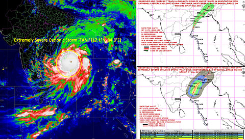
Guwahati: The Indian Meteorological Department (IMD) on Thursday updated through a press statement that yesterday’s extremely severe cyclonic storm over west central Bay of Bengal (BoB) moved north-northeastwards and lay centered at 2.30 pm on May 2, 2019 over the same region near latitude 17.1°N and longitude 84.8°E, about 320 km south-southwest of Puri (Odisha), 170 km east-southeast of Vishakhapatnam (Andhra Pradesh) and 610 km south-southwest of Digha (West Bengal).
It is very likely to move north-northeastwards and cross Odisha Coast between Gopalpur and Chandbali around Puri during the forenoon of May 3, with a maximum sustained wind speed of 170-180 kmph gusting to 200 kmph.
Landfall process is very likely to continue till noon/afternoon of tomorrow. After the landfall the system is very likely to continue to move north-northeastwards, weaken gradually and enter into West Bengal as a Severe Cyclonic Storm with the wind speed of 90-100 kmph gusting to 115 kmph. It is very likely to move further northeastwards and emerge into Bangladesh on April 4 evening as a Cyclonic Storm with wind speed 60-70 kmph gusting to 80 kmph. The cyclone is being tracked by Doppler Weather Radars Vishakhapatnam & Machilipatnam.
Forecast track and intensity are given in the following table:
| Date/Time(IST) | Position (Lat. Degree N/ long. Degree E) | Maximum sustained surface wind speed (kmph) | Category of cyclonic Disturbance |
| 02.05.19/1430 | 17.1/84.8 | 190-200 gusting to 220 | Extremely Severe Cyclonic Storm |
| 02.05.19/1730 | 17.5/85.0 | 190-200 gusting to 220 | Extremely Severe Cyclonic Storm |
| 02.05.19/2330 | 18.3/85.2 | 180-190 gusting to 210 | Extremely Severe Cyclonic Storm |
| 03.05.19/0530 | 19.0/85.5 | 175-185 gusting to 205 | Extremely Severe Cyclonic Storm |
| 03.05.19/1130 | 19.8/85.8 | 170-180 gusting to 200 | Extremely Severe Cyclonic Storm |
| 03.05.19/2330 | 21.3/86.7 | 130-140 gusting to 155 | Very Severe Cyclonic Storm |
| 04.05.19/1130 | 23.0/88.1 | 90-100 gusting to 115 | Severe Cyclonic Storm |
| 04.05.19/2330 | 24.7/89.4 | 50-60 gusting to 70 | Deep Depression |
| 05.05.19/1130 | 26.3/90.8 | 20-30 gusting to 40 | Well Marked Low Pressure Area |
Meanwhile, IMD Guwahati had informed The Sentinel Digital that in Northeastern region, Arunachal Pradesh, Assam & Meghalaya: Light to moderate rainfall at most places with isolated heavy to very heavy falls very likely over Arunachal Pradesh and Assam & Meghalaya on May 4 and 5; with isolated extremely heavy falls over Assam & Meghalaya on May 4. Light to moderate rainfall at many places with isolated heavy falls very likely over Nagaland, Manipur, Mizoram & Tripura on May 4.
It is to be noted that as per Indian Meteorological Department had issued a warning stating that Strong surface wind speed reaching 30-40 kmph is likely to prevail over the North Eastern states on Thursday.
In Assam, Heavy to very Heavy Rainfall is likely to occur on isolated places of Dhubri, Kokrajhar, Goalpara, Bongaigaon, Chirang, Barpeta, Kamrup (R) & Udalguri with isolated Extremely Heavy falls over South Salmara Mankachar & Baksa districts on May 4 and the all above-mentioned districts are being kept on High Alert.
Similarly, Heavy Rainfall is likely to occur at isolated places over Nalbari, Kamrup (M), Darrang, Morigaon, Sonitpur, Cachar and Karimganj districts on the same day and people in the region are asked to remain updated.
On May 5, Heavy to very Heavy Rainfall is likely to occur at isolated places over the districts of Bongaigaon, Chirang, Barpeta, Nalbari, Baksa, Sonitpur & Udalguri districts are being kept on high alert.
Also, Heavy rainfall is very likely to occur at isolated places over Dhubri, Kokrajhar, Goalpara, Kamrup (R), Kamrup (M), South Salmara Mankachar, Nagaon, Hojai, Biswanath, West Karbi Anglong, Jorhat, Majuli, Lakhimpur, Dhemaji, & Dibrugarh districts are being asked to remain updated by the IMD on the same day.