
- Home
- Live Blog
- Breaking News
- Top Headlines
- Cities
- NE News
- Sentinel Media
- Sports
- Education
- Jobs
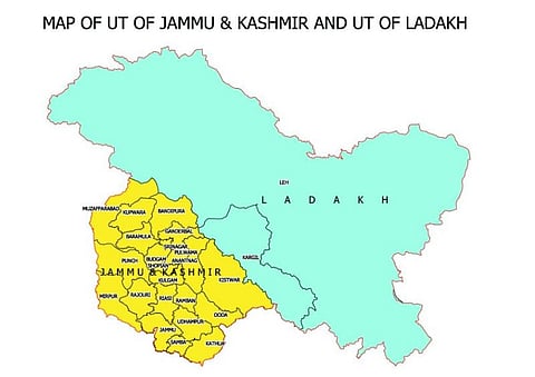
Islamabad: Pakistan on Sunday rejected the political maps of the newly-created Union Territories of Jammu and Kashmir and Ladakh issued by India that include areas of Pakistan occupied Kashmir (PoK), as “incorrect, legally untenable, void” and in violation of UNSC resolutions. In a statement, the Foreign Office said: “Pakistan rejects these political maps, which are incompatible with the UN maps.” Pakistan said that it reiterates that “no step by India can change the disputed’ status of Jammu and Kashmir recognized by the UN”. On Saturday, two days after the UTs of Jammu and Kashmir and Ladakh came into being, the Indian government released their official maps, including territories like Muzaffarabad, Mirpur, and Gilgit-Baltistan that are in PoK. The maps were released as well as a full political map of India by the Union Home Ministry. In a gazette notification, the government also enumerated the territories in Leh district as: “Gilgit, Gilgit Wazarat, Chilas, Tribal territory and Leh and Ladakh, except the present territory of Kargil.” (IANS)