
- Home
- Live Blog
- Breaking News
- Top Headlines
- Cities
- NE News
- Sentinel Media
- Sports
- Education
- Jobs
Kamal Baruah
(The writer can be reached at kamalbaruah@yahoo.com)
Over the centuries people have learnt to live with rivers. The catastrophic floods of rivers killed people from the remotest ages. There was an incident of man-made flood from the Huayuankou event in 1938 when China used flood to protect from the invasion of Japanese killing a million Japanese soldiers and even Chinese citizens. Thereby, Huang-he was China's sorrow. However, China successfully controlled the Huang-he by building overflow channels and taller dykes.
Like the yellow river, the Brahmaputra has been Assam's sorrow. The river has another terrifying story of annual flooding that eats away at the entire economy. The 2,900 km-long trans-boundary river originates as the Yarlung Tsangpo from the Manasarovar Lake. It is fed by the Kailash glaciers in Tibet. It flows 2,840 km in Tibet with tributaries Nyangchu, Lhasa, Nyang andParlung. In Arunachal it is called the Siang, finally appears as Dihang in the plains and gathering the tributaries Dibang and Lohit, it becomes the Brahmaputra in Assam.
The rain-fed Brahmaputra gathers the bulk of its volume from its tributaries of Arunachal (Subansiri, Kameng); Assam (Ranga Nadi, Jia Bhoreli, Puthimari; Bhutan (Manas, Gangadhar); Patkai Hills of Myanmar (Buri Dihing), Nagaland (Dhansiri); Meghalaya (Kopili) and Sikkim (Teesta). In Bangladesh, it is Jamuna from the Ganges (Padma in Bangladesh) and Meghna forming the world's largest delta into the Bay of Bengal. Assam is geographically situated at a lower level ground than other NE plateau. In such a situation, the Brahmaputra cannot contain excessive rain water from its tributaries. Besides it is caused by dams from Bhutan and China.
Understanding the Brahmaputra is yet to be achieved. Ancient Assam witnessed flood only in the north bank. After the great earthquake 1950, the river beds rose as sediments got blocked, causing tremendous changes of riverine topography. As landslides blocked rivers in the mountain, the channels shifted and erosion took place. The river shifted laterally from Pasighat to Goalpara and flood started occurring on both the banks. Being a riverine people, we saw the flood levels going high every year as sand-banks impeded at the mouth of stream.
Brahmaputra isn't just a river, it's a huge sea. It has vastness of water landscape, amazingly 15 km wide. Assam flood is singularly different in terms of duration and magnitude of erosion. It can't be controlled merely by strengthening embankment and anti-erosion measures. As the Brahmaputra flows, people have to live with water and explore new avenues. Besides sorrows, it can raise the economic potential by growing crops in water. Mr SM Huq, a former Director of the Central Water Commission, quoted the above while visiting Assam.
The woes continue as the river is part of Assamese lives. Villagers learnt to live even as it wreaked havoc on their crops and even though they are always under threat.The nature of flood in Assam takes a quantum leap every year. It killed hundreds of human lives and threatened endangered species. Rhinoceros from Kaziranga flee to the Karbi Hills seeking high ground. Onlookers see herds of elephants blocking the National Highway. Helpless deer wander for safety. Floods damages crops. The Brahmaputra has an age-old tendency to flow southward, shifting its channels and traversing its valley which led to the emergence of Majuli as a riverine island during the first half of the 18th century. Lakhs of hectares of land were eroded away by the river and its tributaries. The highly erosion-prone landmass of Majuli has now got reduced to half its original size. The new channels have deteriorated in lower Assam. Palashbari experienced the threat of severe bank erosion in 1954. Two-thirds of Dibrugarh also got submerged in the river.
Flood estimation report for the Brahmaputra basin is never asserted by the Directorate of Hydrology from CWC. However, dredging of the Brahmaputra was undertaken off and on since 1975 which proved unsuccessful. The task is unfeasible since sediments get deposited very fast. The traditional sand embankments can't protect Assam. The cost of such an undertaking would be enormous but it has significance for the loss of human life, damage to property, destruction of crops, loss of livestock and deterioration of water-borne diseases. When flood recedes, the sediments carried by the river remain and fertilize the soil. It brings changes to ponds and fisheries. Could flooding turn into a harbinger of life to farmers? There is no way to stop this abundant water. Let water spill over the plains. Rather, villagers should follow what their forefather practiced. They live by the river.
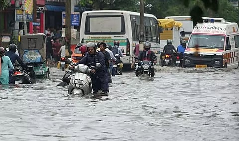
Ironically, Guwahati being the gateway of North-East gets submerged often by urban flood. Owing to heavy rains there is silting from the hills and city channels/drains get silted up. The condition worsens when the Brahmaputra backflows. Unplanned urbanization and unchecked deforestation have taken a toll. The water bodies of Deepor Beel and Borsola Beel have to be freed from massive encroachments, for these are natural water reservoirs. Desilting tanks with cascading at Khanapara might push Meghalaya water downwards rapidly. Interlinking of all cities' springs and streams with Bahini, Mora Bharalu, Lakhimijan and Bharalu, which are connected to the Brahmaputra, would ease the volume of water. A plastic-free city and solid waste management will surely help in mitigating disasters.