
- Home
- Live Blog
- Breaking News
- Top Headlines
- Cities
- NE News
- Sentinel Media
- Sports
- Education
- Jobs
Himangshu Ranjan Bhuyan
(hrbhuyancolumnist@gmail.com)
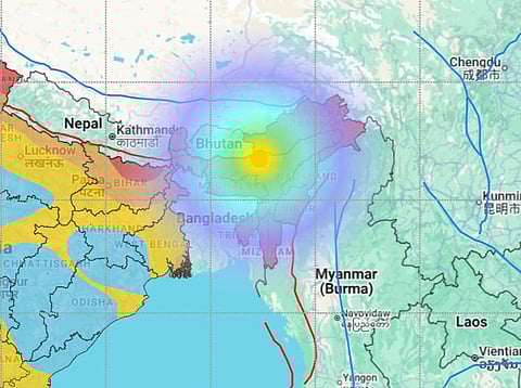
A seismic jolt measuring 5.8 on the Richter scale struck Assam on September 14, 2025, with its epicentre in the Udalguri district at a shallow depth of 5 kilometres, sending ripples of fear across Guwahati and neighbouring regions. Tremors reverberated into West Bengal, Bhutan, and Arunachal Pradesh, evoking widespread panic as residents fled buildings around 4:41 pm. Preliminary assessments from the Assam State Disaster Management Authority revealed no fatalities or extensive structural failures, though minor issues such as wall cracks emerged in districts including Biswanath, Darrang, Hojai, Nalbari, and Sonitpur. Two young girls suffered injuries from a ceiling collapse in a Udalguri hostel, and subsequently aftershocks, including a 2.7 magnitude event at 6:11 pm, amplified the anxiety. Chief Minister Himanta Biswa Sarma promptly updated the public on social media, confirming ongoing surveillance, while Prime Minister Narendra Modi extended central assistance, underscoring a unified governmental approach. This incident, albeit non-devastating, illuminates Assam’s chronic exposure to seismic threats in a region classified under Zone V of India’s seismic zoning map—the most hazardous category—where the Indian plate’s northward thrust against the Eurasian plate at 4-5 cm annually unleashes formidable energies.
Assam’s geological setting amplifies these dangers, positioned near the eastern Himalayan arc and the Indo-Burmese subduction zone, fostering a nexus of faults primed for rupture. Probabilistic seismic hazard assessments (PSHA) for Northeast India, incorporating topography-based shear wave velocity (VS30) values, estimate peak ground accelerations (PGA) ranging from 0.16g to 0.57g, with spectral accelerations (Sa) up to 0.77g, signalling substantial ground shaking potential in a 475-year return period scenario. Historical precedents underscore this peril: the 1897 Shillong earthquake (magnitude 8.1) ravaged infrastructure and altered topography, while the 1950 Assam-Tibet event (magnitude 8.6) claimed over 1,500 lives, dammed the Brahmaputra River, and induced floods and landslides that redefined the landscape. More contemporary quakes, such as the 2021 Sonitpur tremor (magnitude 6.4), inflicted liquefaction, landslides, and indirect fatalities from shock-induced cardiac arrests. The Kopili Fault, a 300-km transverse structure slicing through the Assam Valley into Bhutan, emerges as a critical concern. Recent studies, including 3D structural modelling from focal mechanisms of small-to-moderate events (ML 2.3-6.4), depict it as a deep-rooted, mantle-reaching feature exhibiting transpressional stress with high dip angles, capable of hosting magnitudes up to 7.3 based on accumulated strain since 1943. Over 1984-2019, it generated 11 damaging quakes (M 5.0-6.7) via strike-slip motion, and the February 27, 2025, magnitude 5.0 event near its trace—echoing the 2021 sequence—hints at escalating activity. Optically stimulated luminescence (OSL) dating reveals liquefaction evidence from two events around 480 years ago, suggesting a recurrence interval that could precipitate a major rupture soon. The ‘Assam seismic gap’, dormant since 1950, exhibits low b-values in seismicity analyses, indicating stress buildup in the foredeep, where smaller tremors like the recent one may herald a larger release. Multi-model susceptibility assessments for the 1950 rupture zone classify 40% of the Eastern Himalayan front as very high to high risk, integrating MaxEnt modelling with peak ground velocity (PGV) and Japan Meteorological Agency (JMA) intensities. These possibilities extend beyond isolated quakes; secondary hazards like soil liquefaction in Brahmaputra floodplains, exacerbated by soft sediments, and landslides in hilly terrains could compound devastation, particularly as climate change alters precipitation patterns, potentially increasing event frequency by 2050 when urban exposure swells to 200 million in India per World Bank projections.
Such seismic probabilities cast long shadows over Assam’s developmental aspirations, intertwining natural hazards with economic, social, and environmental trajectories. The state, a pivotal gateway to Northeast India, pursues ambitious growth through initiatives like the North East Region Mega Power Projects and bamboo-based bio-refineries, with Prime Minister Modi’s recent Rs 18,530 crore investments in Brahmaputra bridges and ethanol plants aiming for energy self-sufficiency and industrial uplift. Urbanization surges in Guwahati, a burgeoning metropolis under the Smart Cities Mission, where high-rises and commercial corridors symbolize progress yet amplify vulnerabilities. Non-compliance with IS 1893 seismic codes—due to enforcement lapses and substandard materials—renders unreinforced masonry prevalent in rural and semi-urban pockets susceptible to collapse even in moderate events; the 2021 quake alone tallied crores in damage to tea estates, oil facilities, and transport links, core to Assam’s economy. Tea plantations, sustaining millions, face landslide-induced yield dips, while disruptions to the Numaligarh Refinery or nascent infrastructure like the Kuruwa-Narengi Bridge necessitate recurrent repairs, syphoning resources from health and education. In a flood-prone state already burdened by ethnic strife and poverty, quakes perpetuate displacement, straining welfare nets and fuelling urban migration into quake-vulnerable slums.
Environmentally, tremors hasten erosion in the Brahmaputra basin, blending with hydrological disasters to sterilize farmlands; the 1950 damming precedent warns of amplified flooding under climate variability. Socially, the psychological imprint lingers—residents recount terror of impending doom—disproportionately affecting women, children, and indigenous groups in remote areas like Udalguri, where access to aid lags. Cross-border implications strain ties with Bhutan and Bangladesh, demanding collaborative monitoring. By 2050, unchecked risks could derail Assam’s Viksit Bharat integration, transforming growth hubs into reconstruction zones and entrenching inequality.
Opportunities for fortification abound, however, if Assam embeds resilience into its fabric through multifaceted strategies. Central to this is rigorous enforcement of earthquake-resistant norms per the National Building Code, mandating flexible designs, base isolators, and ductile materials to dissipate energy. Retrofitting campaigns, prioritized for schools, hospitals, and public edifices under the National Earthquake Risk Mitigation Project (NERMP), could avert collapses; subsidies for quake-proof reinforcements using local bamboo—abundant and sustainable—would spur adoption among private builders. Guwahati’s seismic microzonation, leveraging NESAC’s satellite imagery and GIS for liquefaction mapping in floodplains, must guide urban planning, restricting high-rises in high-risk zones and integrating them into the Smart Cities framework. Early warning systems, like the BhooKamp app from the National Centre for Seismology, deliver real-time alerts, but expansion via community radio, SMS, and AI-enhanced networks along the Kopili Fault could provide vital evacuation seconds. The Assam State Disaster Management Plan, harmonized with NDMA guidelines, stresses inter-agency coordination, yet funding shortfalls hinder drills; bolstering the 24/7 seismic monitoring via IMD’s stations and ASDMA’s response centres would bridge this. Community-centric education—annual mock drills on National Disaster Preparedness Day, ‘drop, cover, and hold on’ training in schools, and equipping self-help groups in tribal areas with first-aid kits and essentials—fosters grassroots readiness. Policy innovations, such as techno-legal regimes for construction permits and mainstreaming disaster risk reduction (DRR) into development via the Sendai Framework, address root issues like unregulated mining that induces micro-tremors. International benchmarks, like Japan’s base isolation triumphs, offer blueprints; collaborations with Columbia University on Guwahati’s climate-adaptive DRR exemplify this. The Earthquake Disaster Risk Index (EDRI), factoring topography, exposure, and vulnerability, highlights alarming risks in capitals, urging revised building norms and collateral hazard planning for fires and landslides. By 2030, full compliance and education could halve losses, per NDMA projections, aligning seismic preparedness with sustainable growth.
Assam’s horizon, therefore, pivots on converting these earthquake possibilities from existential threats into drivers of innovation. The September 14 event exposed fissures: rural assessment delays in Udalguri spotlight connectivity gaps, while Guwahati’s urban frenzy underscores awareness deficits. Seismologists like those at IIG emphasize that minor releases, if unheeded, prelude majors; the Kopili’s transpressional regime and historical liquefaction signal an urgent need for recurrence modelling. Embracing green infrastructure—bamboo-reinforced edifices and eco-retrofitting—marries economic vitality with safety, while inclusive policies ensure marginalised voices shape resilient urbanism. Failure invites historical echoes, stalling Assam’s ascent; success, through science-infused governance and communal resolve, forges a bastion against tectonic whims. This seismic saga demands audacious steps to secure a prosperous, unyielding future.
