
- Home
- Live Blog
- Breaking News
- Top Headlines
- Cities
- NE News
- Sentinel Media
- Sports
- Education
- Jobs
Dipak Kurmi
(You can reach the writer at dipakkurmiglpltd@gmail.com.)
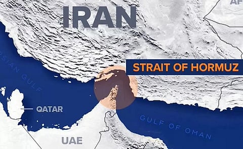
The escalating conflict between the United States and its regional allies against Iran, which ignited on February 28, has fundamentally destabilised the delicate equilibrium of the maritime world. Beyond the kinetic exchange of ordnance, the theatre of operations has shifted toward a more insidious and invisible domain: the disruption of critical shipping and energy supplies through the Strait of Hormuz. This war is being fought not only with steel but with signals, as both sides have witnessed their sophisticated navigation systems go haywire, resulting in surreal digital hallucinations where massive naval vessels appear to be located at inland airports, landlocked regions, or even nuclear power plants. This chaotic reality is the byproduct of pervasive electronic interference, specifically through the mechanisms of GPS spoofing and jamming, which have turned one of the world’s most vital energy corridors into a treacherous labyrinth of misinformation.
To understand the gravity of this digital fog, one must distinguish between Global Navigation Satellite Systems (GNSS) and the specific American Global Positioning System (GPS), though the terms are often used interchangeably in common parlance. While GPS remains the most prevalent architecture, several other constellations provide Position, Navigation, and Timing (PNT) information, including Europe’s Galileo, Russia’s GLONASS, China’s BeiDou, and India’s NavIC. These systems rely on a fragile network of ground infrastructure and satellite constellations that transmit relatively weak signals to receivers. Because these satellite navigation signals possess such a low power threshold, they are remarkably vulnerable to deliberate interference from terrestrial sources, making them a primary target for actors seeking to paralyse an opponent’s logistics without firing a single shot.
The distinction between jamming and spoofing is critical to understanding the strategic nuances of modern electronic warfare. GPS jamming is a relatively blunt instrument; it involves the use of a device to drown out the weak satellite signals with high-intensity “noise” on the same frequency, effectively rendering the receiver deaf. In contrast, GPS spoofing is a far more sophisticated and dangerous offence. Spoofing involves mimicking the genuine GPS signal to provide a pilot or captain with plausible but entirely false location data. This deception can lead to catastrophic errors, forcing pilots to incorrectly account for terrain or altitude and creating a state of profound confusion in the cockpit. While jamming simply indicates that a system is broken, spoofing convinces the operator that they are safe and on course while they are actually drifting toward danger.
In the current West Asian theatre, the scale of this interference has reached unprecedented proportions, according to data from Windward, a prominent maritime intelligence company. On March 7, over 1,650 vessels experienced significant interference in their GPS and Automatic Identification Systems (AIS), representing a staggering 55% increase over the previous week. Intelligence analysts identified at least 30 distinct jamming clusters across Saudi Arabia, Kuwait, the UAE, Qatar, Oman, and Iran, spanning both terrestrial and maritime zones. Satellite imagery has captured the physical manifestation of this digital chaos; shipping clusters that previously moved in orderly patterns have devolved into erratic zigzag formations, as ships’ signals are thrown across multiple erroneous locations.
The operational risks associated with such misleading location data are immense and multifaceted. When ships are presented with false coordinates, they risk being run off course into shallow waters or toward the path of other massive tankers, dramatically increasing the likelihood of collisions or groundings. Furthermore, there is the persistent risk of false compliance alerts in a region where maritime regulations are strictly enforced. While no official confirmation has been issued regarding the ultimate source of this widespread disruption, Iran has long been a primary suspect due to its prior threats to block the Strait of Hormuz. This tactic is an extension of a persistent warfare strategy seen in other contemporary conflicts, such as the Russia-Ukraine war, where electronic interference is used to divert the navigation of drones and precision-guided missiles.
India has not been immune to these electronic tremors, facing its own significant challenges with navigation security. Last November, the Indira Gandhi International Airport (IGIA) in Delhi experienced major flight disruptions when a planned system upgrade coincided with intense regional GPS spoofing. In the absence of a functional instrument landing system, aircraft typically rely on GPS-based Required Navigation Performance (RNP) guidance, but the spoofing rendered these backups unreliable. Government data provided to the Lok Sabha revealed that between November 2023 and February 2025, approximately 465 incidents of GPS interference were reported in India’s sensitive border regions, particularly in the Amritsar and Jammu sectors, highlighting the domestic stakes of this global electronic arms race.
Navigating this digital minefield requires a return to foundational principles and the deployment of resilient alternative technologies. For aircraft experiencing spoofing mid-air, pilots must often revert to Inertial Navigation Systems (INS), which utilise gyroscopes and accelerometers to track an aircraft’s position relative to its last known location without external signals. In extreme scenarios, the aviation community still recognises the value of celestial navigation, or “dead reckoning”, although these are increasingly rare in a high-tech age. Organizations like IATA have emphasized the necessity of maintaining conventional ground-based navigation aids (GBNAs) and Minimum Operating Networks (MON) as a vital mitigation strategy until the global aviation ecosystem can develop more robust protections against GNSS interference.
Maritime crews face a similar challenge, as modern ships typically operate on autopilot systems that follow autonomous, GPS-based courses. When spoofing is suspected, the ship’s crew must immediately transition to manual helm control and utilise terrestrial navigation. This process involves manual position fixing using land-based aids such as lighthouses and radars to maintain situational awareness in the absence of reliable satellite data. To make themselves less vulnerable to failures, shipping companies are increasingly looking to use multi-constellation GNSS receivers, which can check data from Galileo, BeiDou, and GLONASS to spot problems caused by local GPS jamming or spoofing.
The Indian military has taken a decisive step toward electronic sovereignty with the deployment of the indigenous Navigation with Indian Constellation, known as NavIC. Developed by the Indian Space Research Organisation (ISRO), NavIC is specifically engineered to provide precise positioning and timing services across the Indian subcontinent and extending up to 1,500 km beyond its borders. By relying on a regional constellation rather than the global American GPS, NavIC offers a layer of protection against the broad-spectrum jamming that currently plagues the Middle East. As the war in the Gulf continues to demonstrate the fragility of the global digital order, the ability to maintain an independent and resilient PNT infrastructure has become a cornerstone of national security and economic survival.
The electronic sabotage occurring in the Strait of Hormuz serves as a harbinger of the future of conflict, where the battle for the electromagnetic spectrum is as vital as the battle for the sea lanes. The ability to manipulate an adversary’s perception of physical reality through spoofing represents a terrifying evolution in warfare, one that challenges the very foundations of trust in automated systems. As the maritime and aviation industries grapple with these disruptions, the transition toward multi-layered, redundant navigation architectures is no longer a luxury but an absolute necessity. The silent war of signals may not produce the same immediate visual impact as a missile strike, but its potential to cripple the global economy and cause catastrophic accidents makes it one of the most significant threats of the twenty-first century.
