
- Home
- Live Blog
- Breaking News
- Top Headlines
- Cities
- NE News
- Sentinel Media
- Sports
- Education
- Jobs
Staff Reporter
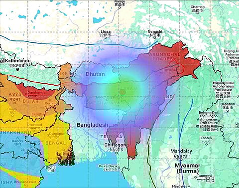
GUWAHATI: A tremor with a magnitude of 5 on the Richter scale rattled Assam and its neighbouring states at 2.25 am on Thursday. The epicentre of the earthquake was in the Morigaon district at a depth of 16 km.
As the shaking continued for several seconds, residents were a panicked lot in the state. As people were fast asleep when the tremor occurred, lasting for several seconds, many people had to go out and stay without sleeping for a period with the fear of aftershocks.
The fear thickened with the occurrence of several earthquakes in February. The Northeast experienced as many as 11 earthquakes in January this year.
The preliminary report of the National Centre for Seismology, Ministry of Earth Sciences, said, "An earthquake of magnitude 5.0 occurred in the Marigoan District, Assam, on February 27, 2025, at 02:25:40 hours (IST) at a depth of 16 km with an epicentre at 26.28 N, 92.24 E. The event was recorded by the National Centre for Seismology and located 58 km northeast of Guwahati city in Assam and 68 km southeast of Tezpur, 202 km west-southwest of Jorhat. The preliminary analysis shows that the events are located near the Kopili Fault and closer to the April 28, 2021, M 6.4 Sonitpur earthquake. The preliminary fault plane solution derived from moment tensor inversion suggests a strike-slip fault."
According to the preliminary report, the historical and instrumentally recorded earthquake data (NCS catalogue) reveal that the region is affected by moderate to large earthquakes. The most prominent events among these are M 6.4 on April 28, 2021; M 6.4 on September 21, 2009; the Bhutan earthquake; and the July 29, 1960, Assam earthquake of M 6.0. In addition to the above, noteworthy earthquakes originating in Assam and neighbouring regions are often felt in the region with slight to strong intensity. The occurrence of earthquakes in the region is attributed mainly to the tectonic sources in the Himalayas, such as the Himalayan Frontal Thrust (HFT), Main Boundary Thrust (MBT), Main Central Thrust (MCT), Kopili Fault, and Dhubari Fault. Seismologically as well as geologically, it is evidenced that the region has been quite active.
The Assam region falls in the high seismic zone V of the seismic zoning map of the Bureau of Indian Standards (BIS).
The earthquake was widely felt across Assam and neighbouring states, with calculated intensities ranging from II to V on the Modified Mercalli Intensity (MMI) scale within a distance of approximately 0 to 300 km from the epicentre. A total of 37 felt reports were received through the NCS website and mobile app, indicating intensities between III and VI on the MMI scale.
Also Read: 5.1 Magnitude Earthquake Strikes Bay Of Bengal, Tremors Felt In Kolkata
Also Watch: