- Home
- Live Blog
- Breaking News
- Top Headlines
- Cities
- NE News
- Sentinel Media
- Sports
- Education
- Jobs

Flood inundation of Guwahati mapped
Staff Reporter
GUWAHATI: A team of the North Eastern Regional Node for Disaster Risk Reduction (NER-DRR) of the North Eastern Space Applications Centre (NESAC), Umiam, Meghalaya, conducted flood inundation mapping of the Guwahati metropolitan area using satellite data recently. The mapping has found that ‘rapid urbanisation, poor drainage, and encroachments on natural water bodies have made the city increasingly vulnerable to waterlogging and flash floods during heavy rainfall events’. The NER-DRR team conducted the mapping on May 19, 2025, using Sentinel 1 SAR Satellite Data.
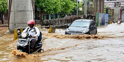
According to the mapping, on May 20, 2025, a large part of the Guwahati area was submerged in urban floods due to continuous heavy rains, resulting in the disruption of the normal life of the people. Accumulation of water was reported from almost all peripheral roads in the city. By May 19, 2025, approximately 720.06 hectares of land had already been inundated, and the situation worsened further the following day. NESAC has conducted an analysis to see the water inundation in the urban periphery of Guwahati city through temporal satellite data.
A persistent upper-air cyclonic circulation has been observed over central Assam for five days before May 20, 2025, extending up to 1.5 km above the mean sea level. Additionally, another cyclonic circulation has developed over North Bangladesh and its neighbouring areas, also at 1.5 km above the mean sea level. These synoptic conditions have been favourable for convective system formation, with multiple systems originating in the northwestern part of Northeast India, particularly over Nepal, Sikkim, and the Sub-Himalayan region of West Bengal. Around midnight, a mesoscale convective system formed and moved over western Assam, strengthening significantly by 3 am on May 20, 2025. By 5:30 am, it impacted the Kamrup district of Assam and Ri Bhoi district of Meghalaya, bringing moderate to heavy rainfall across multiple locations. The rainfall persisted until 9:30 am, after which the system progressed eastward.
Heavy rainfall has been recorded by multiple stations of Assam and Meghalaya, a few of which can be observed. The rainfalls at the stations are mostly recorded during the morning of 20th May, 2025. Precipitation obtained from Integrated Multi-satellite Retrievals for the Global Precipitation Measurement (GPM) early run product also showed precipitation over extensive parts of Meghalaya and Assam as the synoptic condition persisted; similar heavy rainfall was likely to happen over Assam and Meghalaya in the next 24 hours.
According to the mapping, accumulated rainfall obtained from 19th May 2025 (8:30 am) to 20th May (8:30 am) was – Guwahati AP (Kamrup, Assam) 99.6 mm, Khanapara (Kamrup, Assam) 52 mm, Rangia (Kamrup, Assam) 21 mm, Nongpoh (Ri Bhoi, Meghalaya) 30.3 mm, Barapani (Ri Bhoi, Meghalaya) 48.1 mm.
The extent of flood inundation across various administrative circles in and around Guwahati was measured in hectares and highlights the severity of both rural and urban flooding in the region. Notably, North Guwahati Circle recorded the highest flood-affected area, with 259.61 hectares inundated, followed by Hajo Circle (175.92 ha) and a significant portion of Azara Circle (161.57 ha). Urban areas such as Guwahati Circle (33.69 ha), Dispur Circle (22.18 ha), and parts of Azara Circle (22.49 ha) also experienced considerable inundation, underscoring the growing challenge of urban flooding in Guwahati. Rapid urbanization, poor drainage, and encroachments on natural water bodies have made the city increasingly vulnerable to waterlogging and flash floods during heavy rainfall events. In contrast, areas like Sipajhar and Sonapur Circle witnessed minimal impact, with less than 0.1 hectares flooded. This data is crucial for developing targeted flood management strategies, particularly to address the rising frequency of urban floods in the Guwahati Metropolitan Area.
Also Watch: