
- Home
- Live Blog
- Breaking News
- Top Headlines
- Cities
- NE News
- Sentinel Media
- Sports
- Education
- Jobs
STAFF REPORTER
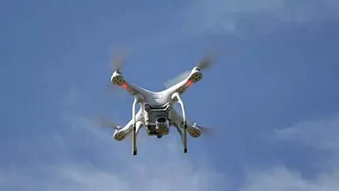
GUWAHATI: Assam is trying to use drones for surveillance of floods, erosion, embankments, droppings essentials, mapping, a survey of highlands etc., from the coming monsoon. It will be the first of its kind in the flood-prone state. NESAC (North Eastern Space Application Centre), Umiam in Meghalaya, will make five drones for Assam.
NESAC is a joint initiative of DoS (Department of Space) and (NEC) North Eastern Council. It helps in augmenting the development process in the region by providing advanced space technology support.
ASDMA (Assam State Disaster Management Authority), on behalf of the State government, has given the assignment for making the five drones to NESAC for their application in the coming monsoon.
According to ASDMA sources, three drones are for aerial surveillance during floods and other emergencies. While one is mapping, the other is for dropping essentials during emergencies or disasters. ASDMA has set the target to use the three surveillance drones from the coming flood season. Floods perennially visit the State in April-May. The sources, however, said that the drones for mapping and dropping would take some time as NESAC would have to customize them (make them suitable for the purpose).
Apart from surveillance of floods, erosion etc., the drones will help in the hill-top survey. The total cost of the project is Rs 1.27 crore.
Also Watch:
