
- Home
- Live Blog
- Breaking News
- Top Headlines
- Cities
- NE News
- Sentinel Media
- Sports
- Education
- Jobs
Staff Reporter
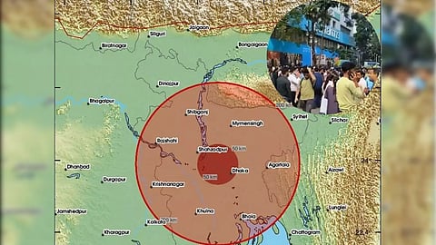
Guwahati: In the morning today, Assam experienced jolts from an earthquake of Magnitude 5.7 that occurred at 10:08:26 IST, near neighbouring country Bangladesh's capital, Dhaka. The quake also shook some of the other NE states, with the epicentre located at a distance of 75 km west of Agartala, Tripura, and 247 km south of Shillong, Meghalaya.
Residents of Guwahati felt the tremors from the quake for several seconds. However, there are no reports of any damage caused by the quake.
As per the Preliminary Earthquake Report of India's National Center for Seismology (NCS) regarding the M 5.7 quake, "An earthquake of magnitude M 5.7 occurred at 10:08:26 IST in Dhaka, Bangladesh, whose epicentre is at 23.77°N and 90.51°E with a depth of 10 km. The epicentre is located 75 km West of Agartala, Tripura, 247 km South of Shillong, Meghalaya, and 246 km northeast of Kolkata, India. The area is seismically active and associated with the Rakhine-Bangladesh megathrust (RBM), which is the inferred deformation front of the Chittagong-Myanmar fold and thrust belt (CMFB).
"The seismic data analysis suggests that the epicentre is located in close proximity to the Rakhine-Bangladesh Megathrust (RBM), a major convergent boundary accommodating the ongoing collision between the India Plate and the Burma-Sunda microplates. The source region is characterized by significant structural heterogeneity, including accretionary wedge deformation, fold-thrust belts, and strike-slip segmentation, which collectively provide a favourable tectonic setting for the occurrence of the event.
"Preliminary waveform inversion results yield a fault plane solution consistent with a thrust mechanism, with the nodal plane orientation closely aligned to the RBM thrust geometry. This suggests that the rupture likely propagated along the shallow portion of the megathrust, consistent with the regional tectonic stress regime.
"The recorded earthquakes as per the EQ Catalogue of NCS reveal that the region is associated with moderate earthquakes. The seismicity observed in the region is attributed to the dynamics of the shallow megathrust, which constitutes the only ocean-continent subduction zone where the near-trench region is completely exposed on land. Felt reports of maximum intensity of IV (MMI scale) in the epicentral region and minimum intensity of II (MMI Scale) have been reported from around 390 km from the epicentre."
The earthquake was widely felt in Kolkata and the northeastern region of India, with more than 7 felt reports received within one hour through the NCS website and mobile app. The intensity of this earthquake ranges between II and VII on the Modified Mercalli Intensity (MMI) Scale, the report also stated.
The report went on to state that there was no damage reported until Friday evening in the Indian cities due to the November 21 Dhaka, Bangladesh, earthquake, including Kolkata, despite perceptible jolts felt by the people of the state of West Bengal and neighbouring states of India. It is so because the ductile sediments and several water bodies through which seismic waves passed through may have reduced the intensity of earthquake shaking that arrived at Indian cities.
Also Read: Bodo Bodies Urge Government to Implement Accord and Pass Amendment Bill
