
- Home
- Live Blog
- Breaking News
- Top Headlines
- Cities
- NE News
- Sentinel Media
- Sports
- Education
- Jobs
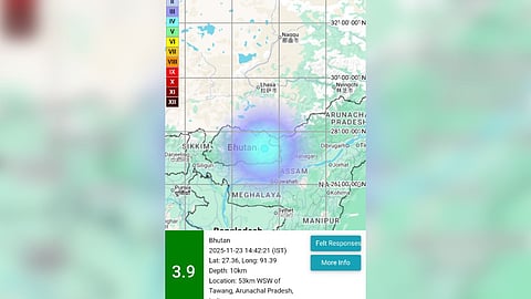
Thimphu: A mild earthquake measuring 3.9 on the Richter scale struck Bhutan on Sunday afternoon, according to the National Center for Seismology (NCS). The tremor was recorded at 14:42:21 IST, with an epicentre located at 27.36°N latitude and 91.39°E longitude, at a depth of 10 km.
The NCS shared the details in a post on X, confirming that the quake originated within Bhutan’s seismically active Himalayan zone. Shallow earthquakes, such as Sunday’s event, are generally more intense because seismic waves travel a shorter distance to the surface, causing stronger ground shaking and increasing the potential for structural damage.
This is the second earthquake to hit Bhutan in recent weeks. On October 9, the country experienced a 3.1-magnitude tremor, recorded at a depth of 5 km, also reported by the NCS.
Bhutan lies in one of the world’s most active seismic zones, shaped by the young and constantly shifting Himalayan mountain system. As a result, earthquakes remain one of the most imminent natural hazards in the country.
Beyond seismic threats, Bhutan also faces several other environmental risks. Glacial Lake Outburst Floods (GLOFs), intensified by global warming, pose a major danger to downstream communities. Seasonal strong winds, which have grown more unpredictable due to climate change, caused extensive damage during the 2011 and 2013 windstorms.
Additionally, landslides, flash floods, and forest or structural fires frequently disrupt life across Bhutan, the Asian Disaster Reduction Centre has stated.
